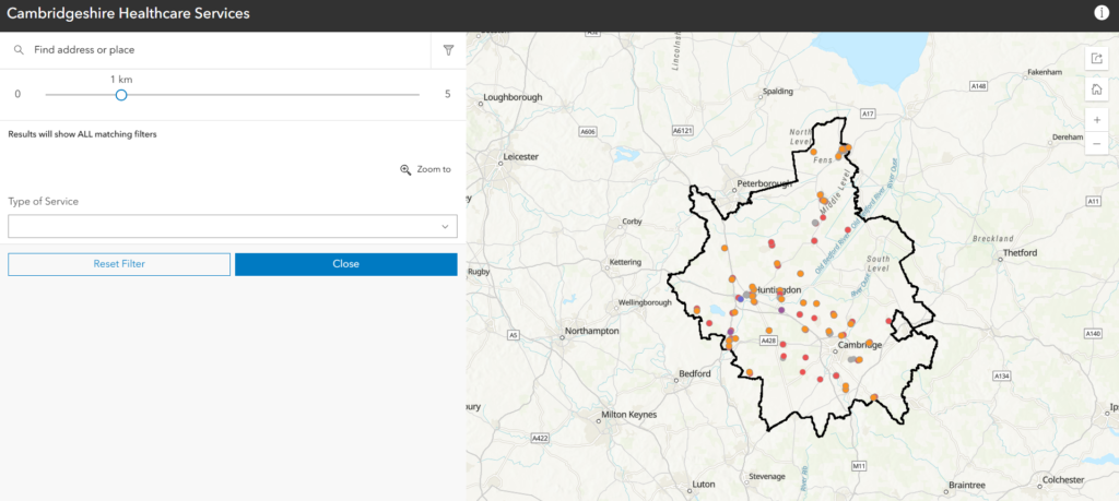
I decided to update a previously completed AGOL Dashboard showing Medical Services available within North Central London.
The new app uses the Nearby Instant App from AGOL and can be found here. Users can input a location or use their current location, and then filter locations by services, and also by distance from their chosen location.
The script can be found here.
There were a few reasons why I decided to do this:
– I thought it would be good to update this for Cambridgeshire.
– I needed to change the code, as the initial code used the arcpy Python library, which I no longer have access to.
– I also wanted to update the code, as the original code ran on a AGOL Python notebook, and I wanted my new code to run on my Raspberry Pi, as it would be easier for this code to be automated at a future date.
1 – Had to create a new Postcodes file in order to act as a filter for Cambridgeshire.
2 – Changed the co-ordinates for my NHS facilities API.
3 – Combined all the required datasets into a single pandas dataframe (Clinics, Dentists, GPs, Hospitals, Opticians, Pharmacies).
4 – Pulled out the contact phone number from the Contacts field, which contained phone numbers, fax numbers, websites etc.
5 – Created a new dataframe and extracted the services, which were originally in a wide format into a long format. This increases the data size, but makes it easier to filter by service type.
6 – Created a new dataframe and extracted the opening times, from a wide format into a long format.
7 – Used the geopandas library to create a geodataframe from a normal dataframe.
8 – Created a shapefile for each geodataframe.
9 – Zipped the shapefile files for easier use.
10 – Emailed the zipped shapefiles for myself so that I can upload them to AGOL.
Please let me know your thoughts, or if you want me to create one for a particular part of the country.