So what is Geospatial Artificial Intelligence (GeoAI)? Essentially it is the fusion of AI technologies with geospatial data and systems. This would allow more sophisticated analysis to be carried out, which to date, either has not been possible, or would take a much longer time to process.
Key Definitions
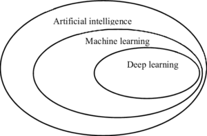
Artificial Intelligence (AI) uses computers to mimic human intelligence by using logic, decision trees and if-then rules.
Within the field of AI is machine learning (ML), which uses statistical techniques allowing computers to carry out improved analysis. One example of this would be supervised classification of satellite imagery to identify ground types such as concrete, water, grass, etc.
Within ML is deep learning (DL), which uses algorithms for software to train itself in skills such as speech and image recognition, through the use of neural networks.
Possible Uses
One use would be for the extraction of building footprints from satellite or aerial imagery. If a new building is found within an area of interest, then the GeoAI could search through its imagery archive to find the structure being built and extract floor plans for the whole building. Additionally this tool could be used for rapidly ascertaining compound extents and numbering them within an area of operations.
Another possible use would be the identification of ‘safe lanes’ through anti-personnel minefields in war zones. Usually the local population will have knowledge of the location of these devices. There may be local ad hoc signs of mines, such as white rocks and arrows on the ground. A GeoAI would be able to compare imagery from different dates to identify ‘paths of desire’ which could identify a safe route.
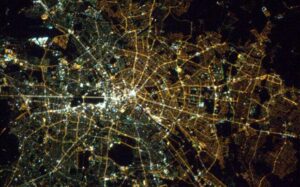
The identification of socio-economic zones would be useful within an urban setting. An example of this can be seen within this imagery of Berlin, denoting the partition of East and West Berlin through the use of streetlights. With enhanced technology and greater resolution, then further refinement of socio-economic status can be made.
During times of civil disturbance, then GeoAI could be used to search for tweets, identifying key words and then plot them on a map. This could then be used to ascertain the current location of any protestors, as well as their possible future intentions. Ideally surveillance of tweets may be able to identify possible hot spots relating to civil disturbance and allow authorities to prevent a riot before it starts.
GeoAI is currently being used within Germany in order to show roads with high traffic and then use this knowledge to predict which roads and areas are the top priority for maintenance.
Concerns
There are several high profile technologists who are concerned about the rise of AI, especially if it is allowed to progress without any safeguards.
Additionally, there are concerns about AI and the potential for job losses within certain fields. While there may not be an office of T800s completing paperwork, there may be a computer buzzing away in a corner, answering HR queries and processing claims.

Within AI, training data is used to teach the AI how to identify certain features and objects. But if the training data is incorrect, or widely biased, then the output will also be incorrect, leading to poor conclusions being drawn from the data.
Additionally AI has been shown to be able to lie, and also of under stating its own capabilities. ChatGPT has also been shown to provide incorrect information in certain circumstances.
Conclusion
With great power, there must also come great responsibility. As with all new technologies, there is the promise of technical progress, but also the threat of the loss of jobs. There should also be safeguards placed onto AI, and care taken when examining any data provided by AI.